How is sound used to study the Earth’s history?
At the bottom of the ocean, there are layers of sediments that contain information about the Earth’s history. Sound is used to map and characterize these sediment layers. Sound is used to select the precise locations for coring or drilling sediment samples to study the history of Earth’s climate and ocean. Scientists also use sound to answer questions such as how and where earthquakes occur, how submarine volcanoes form, and what effects their eruptions have.
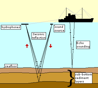
The layers of the seafloor are examined with seismic reflection and seismic refraction (also called wide angle seismics). Echosounding is a basic type of seismic reflection. Echosounding is used to measure the depth of the water. High-frequency echosounders (12,000 Hz) are used to measure the depth to the seafloor. A sound pulse is sent from a ship and that sound reflects off the seafloor and returns to the ship. The time the sound takes to travel to the bottom and back is used to calculate the distance to the seafloor (See the section about Sonar). Low-frequency echosounders (1,000 to 6,000 Hz) can penetrate a short distance into the seafloor, up to approximately 100 meters, to study the upper sediment layers (see Sub-bottom Profiler).
Seismic reflection uses a stronger sound signal and lower sound frequencies (10-50 Hz) than echosounding in order to look deeper below the seafloor. The sound pulse is often sent from an airgun array towed behind a slowly moving ship. Airguns rapidly release compressed air, forming a bubble. This bubble formation produces a loud sound (See Airgun).

This is a picture of the bubble from an airgun off the U.S. Coast Guard Cutter Healy. Image courtesy of Paul Henkart, Scripps Institution of Oceanography.
This is the sound of air guns operating off Sable Island, Nova Scotia, but being recorded many thousands of kilometers away on the Mid-Atlantic Ridge. Note: This sound has been sped up by a factor of ten.
Courtesy of NOAA Pacific Marine Environmental Laboratory VENTS Program
The sound from the airgun travels down to the seafloor. Some of the sound reflects off the seafloor but some of the sound penetrates the seafloor, sometimes as much as 20-30 km below it depending on how the array is designed. The sound that penetrates the seafloor may also reflect off layers of sediment or rock within the seafloor. The reflected sounds travel back up to the surface. The ship also tows a number of hydrophones (called a towed array or streamer) which detects the reflected sound signal when it reaches the surface. They use many hydrophones to hear weaker reflections from deeper in the Earth.

Picture of a streamer being deployed. Image courtesy Schlumberger (www.slb.com).
The time it takes the sound to return to the ship can be used to find the thickness of the layers in the seafloor and their position (sloped, level, etc). It also gives some information about the composition of the layers. By towing multiple hydrophone streamers separated by 50-200 m, scientists can create three-dimensional images of the Earth’s sediment layers. This technique is called multi-channel seismics.
Seismic refraction gives more information about the layers. Sound pulses that enter the seafloor are both reflected and refracted (or bent) as they pass into different layers. The refracted sound pulse follows a complex path. With seismic refraction, the density of the layers can be determined.

Seismic reflection and refraction can also be done with an instrument on the seafloor called an Ocean Bottom Seismometer (OBS). This instrument is placed on the seafloor and uses sound from artificial and natural sources. A seismic survey may make use of both shipboad measurements and measurements from an array of ocean bottom seismometers.
Scientists use the seismic reflection and refraction data for many studies, including reconstructing past sea-level changes, predicting the location of future undersea earthquakes, and understanding how oceanic crust is formed at mid-ocean ridges. As sea level rises, the water depth increases, submerging land where new ocean sediments are deposited. However, if sea level falls, sediments on the seafloor are exposed and may be eroded away. By using sound to map the layers and sampling sediments to date the layers, the history of sea-level change can be estimated.

Cross-section of a subduction zone. From the USGS publication, This Dynamic Planet.
The world’s largest earthquakes occur tens of kilometers below the seafloor where two tectonic plates come together at subduction zones. When the two plates move relatively smoothly past each other, all is well. However, if the two plates become locked, stress is built up that is eventually released during an earthquake. The massive earthquake along the Sumatra subduction zone caused the December 26, 2004 tsunami that killed over 185,000 people, with thousands more still missing. Sound can show which regions are locked and suggest the amount of plate movement that has occurred in the past, providing insight into the potential for earthquake and tsunami damage in the future.

The Mid-Atlantic Ridge. From the USGS publication, This Dynamic Planet.
Nearly 70 percent of the Earth’s crust is formed along the mid-ocean ridge system. New three-dimensional sound data show that the mid-ocean ridge in the Pacific, called the East Pacific Rise, has a magma chamber that is only a few kilometers wide and just tens of meters thick, but that stretches along the ridge for many tens of kilometers. In addition, it was found that some of the largest magma chambers occurred in valleys on the mid-ocean ridge – a surprise to researchers who had thought the magma chambers would be where the seafloor was highest. Future studies are very likely to bring about more new and important discoveries.

A top-down view of an overlapping spreading center along the East Pacific Rise. The darker colors represent seafloor topography (blues deeper seafloor and reds higher areas). The colors in the bright boxes represent reflectivity at approximately 2 km below the seafloor, revealing the location of the magma chamber. From the Lamont-Doherty Earth Observatory publication, Imaging Earth History.
Additional Links on DOSITS
- Airgun
- How is sound used to explore for oil and gas?
- How is sound used to map the sea floor?
- Reflection
- Refraction
- Marine Vibroseis
Additional Resources
- A Trans-Arctic Geophysical Expedition.
- Imaging Earth History Beneath the Ocean Floor.
- NOAA Tsunami Warning Center.
- USGS Earthquake Hazards Program – 2004 Sumatra earthquake information.
- USGS Earthquake Hazards Program, Topics – Northern Sumatra M9.0 – December 26, 2004