How is sound used to explore for oil and gas?
Oil and gas are found in deposits below the seafloor. Millions of years ago, tiny plants and animals died and were buried by layers of sand and silt. Over time, as they are buried by more material, heat from the Earth’s interior and pressure from overlying sediments turn the plant and animal remains into oil and gas. The oil and gas flow into tiny empty spaces in the surrounding rocks, similar to water being absorbed by a wet sponge. A layer of solid rock, salt, or clay traps the oil and gas and prevents them from escaping. People use sound to map sediment and rock layers. They look for structures such as salt domes that can trap oil and gas and for the characteristic signals that indicate the presence of an oil or gas deposit.
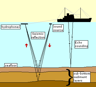
The layers of the seafloor are examined with seismic reflection and seismic refraction (also called wide angle seismics). Echosounding is a basic type of seismic reflection. Echosounding is used to measure the depth of the water. High-frequency echosounders (12,000 Hz) are used to measure the depth to the seafloor. A sound pulse is sent from a ship and that sound reflects off the seafloor and returns to the ship. The time the sound takes to travel to the bottom and back is used to calculate the distance to the seafloor (See the section about measuring water depth). Low-frequency echosounders (1,000 to 6,000 Hz) can penetrate a short distance into the seafloor, up to approximately 100 meters, to study the upper sediment layers (see Sub-bottom Profiler).
Seismic reflection uses a stronger sound signal and lower sound frequencies (10-50 Hz) than echosounding in order to look deeper below the seafloor. The sound pulse is often sent from an airgun array towed behind a slowly moving ship. Airguns rapidly release compressed air, forming a bubble. This bubble formation produces a loud sound (see Airgun).

This is a picture of the bubble from an airgun off the U.S. Coast Guard Cutter Healy. Image courtesy of Paul Henkart, Scripps Institution of Oceanography.
This is the sound of air guns operating off Sable Island, Nova Scotia, but being recorded many thousands of kilometers away on the Mid-Atlantic Ridge. Note: This sound has been sped up by a factor of ten.
Courtesy of NOAA Pacific Marine Environmental Laboratory VENTS Program
The sound from the airgun travels down to the seafloor. Some of the sound reflects off the seafloor but some of the sound penetrates the seafloor, sometimes as much as 20-30 km below it depending on how the array is designed. The sound that penetrates the seafloor may also reflect off layers of sediment or rock within the seafloor. The reflected sounds travel back up to the surface. The ship also tows a number of hydrophones (called a towed array or streamer) which detects the reflected sound signal when it reaches the surface. They use many hydrophones to hear weaker reflections from deeper in the Earth.

Picture of a streamer being deployed. Image courtesy Schlumberger (www.slb.com).
The time it takes the sound to return to the ship can be used to find the thickness of the layers in the seafloor and their position (sloped, level, etc). It also gives some information about the composition of the layers. By towing multiple hydrophone streamers separated by 50-200 m, scientists can create three-dimensional images of the Earth’s sediment layers. This technique is called multi-channel seismics.
Seismic refraction gives more information about the layers. Sound pulses that enter the seafloor are both reflected and refracted (or bent) as they pass into different layers. The refracted sound pulse follows a complex path. With seismic refraction, the density of the layers can be determined.

Seismic reflection and refraction can also be done with an instrument on the seafloor called an Ocean Bottom Seismometer (OBS). This instrument is placed on the seafloor and uses sound from artificial and natural sources. A seismic survey may make use of both shipboad measurements and measurements from an array of ocean bottom seismometers.
Features in the seafloor layers indicating that oil and gas might be contained in the rocks include salt domes and seeps. Salt domes were created when regions in the ocean repeatedly dried out. With all of the water gone, the salt in sea water was left as a layer. Over time, sea level rose again and the salt was buried by sediments. When salt is put under a lot of pressure and heat from overlying layers, it acts very similar to material in a lava lamp, gurgling and bubbling upward through the rocks above it. When it gets to the top, it forms an impenetrable layer that can trap oil and gas. Salt domes can be found using seismic reflection and refraction because of their unique shape and composition.
Seeps occur when oil and gas escape from the seabed and rise through the water column to the sea surface. Here is a picture of a methane seep in the Gulf of Mexico:

This image shows a large plume of methane-rich water, visible as a dark cloud, extending from the seafloor hundreds of meters up into the water column. At the base of the thermocline, some of the gas bubbles are trapped forming a horizontal layer of methane-rich water in the upper water column. Image by Mandy Joye, University of Georgia. From NOAA Ocean Explorer: Expedition to the Deep Slope (oceanexplorer.noaa.gov/explorations6mexico/welcome.html.
Scientists are using sub-bottom profilers to see what happens to oil and gas once they get into the water column. They are finding that some very small animals survive by using the oil and gas as food. The study of methane seeps may be a significant discovery in understanding the release of this greenhouse gas into the atmosphere.
Additional Links on DOSITS
- Technology Gallery > Airgun
- Technology Gallery > Echosounder
- Technology Gallery > Hydrophone
- Technology Gallery > Hydrophone Array
- Technology Gallery > Marine Vibroseis
- People and Sound > How is sound used to study the Earth’s history?
- People and Sound > How is sound used to map the sea floor?
- Science of Sound > Reflection
- Science of Sound > Refraction
Additional Resources
- NOAA Ocean Explorer: Expedition to the Deep Slope
- Schlumberger Oilfield Glossary: Salt dome
- Wikipedia: Salt dome