How is sound used to transmit data underwater?
Computers use digital data to transmit and receive information including e-mail messages and Internet web pages. Is it possible to transmit this kind of data underwater? Can a submerged submarine send and receive e-mail? Submarines do not have telephone or cable connections, and radio signals do not propagate underwater, so a submarine relies on sound to send and receive digital data.
Basic acoustic communication model. Diagram courtesy of Benthos, Inc.
The DOSITS page on communicating underwater explains how underwater telephone systems use sound to communicate underwater. These systems produce very low quality signals, similar to poor telephone connections that cellular phones may experience. Telephone modems allow computers to transmit and receive information over telephone lines, however, they have small data transmission rates, and do not work very well with poor connections. Special acoustic modems that can successfully transmit digital data underwater have been developed. These modems convert digital data into underwater sound signals that can be transmitted between two submerged submarines or between a submerged submarine and a surface ship. These digital signals can represent words and pictures, allowing submarines to send and receive communications. Underwater acoustic modems are relatively slow compared to telephone or cable modems on land. Nonetheless, this technology is very important because it provides an accurate and efficient means to send and receive data underwater.
Acoustic links are used to control underwater instruments and acquire the data remotely. Diagram courtesy of Benthos, Inc.
Autonomous vehicles working under the ice can be controlled and their data can be transmitted to a topside station using underwater acoustic links. Diagram courtesy of Benthos, Inc.
In addition to submariners, researchers also need to send and receive data underwater. Oceanographers use acoustics to control underwater instruments and acquire the data that they collect remotely. This technology can also be used to control small, unmanned submarines, called Autonomous Undersea Vehicles (AUVs), and get data back from them in real-time. These vehicles are used for oceanographic research and other purposes.
Underwater data links can also be combined with satellite data links to transfer data in real-time from instruments on the seafloor to scientists ashore. One application of this technique is to provide early warnings of tsunamis generated by undersea earthquakes. Tsunami waves are generated when an earthquake causes the seafloor to move. The waves can cause great damage when they build in height as they come ashore. Pressure sensors deployed on the seafloor can detect tsunamis. The U.S. National Oceanic and Atmospheric Administration (NOAA) Deep-ocean Assessment and Reporting of Tsunamis (DART) program has installed bottom pressure sensors near regions with a history of tsunami generation to allow researchers to monitor for and predict tsunami waves. The first four DART buoys began operating in 2000. As of 2020, NOAA maintains a network of 39 DART buoy stations, with 32 located in the Pacific Basin and seven in the Atlantic Basin. There are an additional 21 DART and non-DART buoys deployed with international partners to monitor for tsunamis.
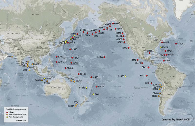
DART buoy locations. The network of 39 stations provides coastal communities in the Pacific, Atlantic, Caribbean, and the Gulf of Mexico with faster and more accurate tsunami warnings. Twenty-one other DART and non-DART buoys are operating with international partners. Image credit: NOAA NCEI 2018. An interactive map with real-time data can be found at the National Data Buoy Center.
Pressure data from seafloor bottom pressure recorders are transmitted to near-by surface buoys via acoustic data links using underwater modems. The data are then relayed to researchers on land in real-time via satellite. The data are used to provide early warnings of a tsunami before it comes ashore.
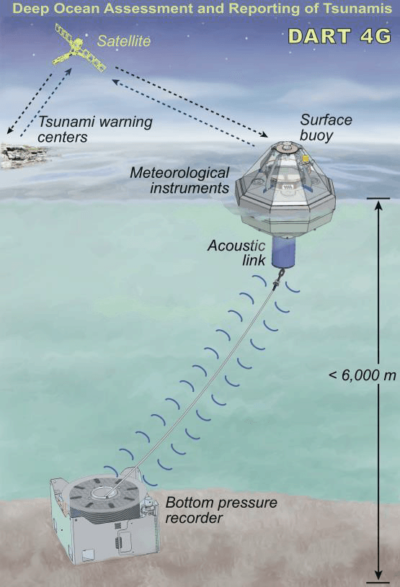
Schematic of a NOAA DART 4G Buoy Station. Each DART station consists of a bottom pressure sensor anchored to the seafloor and a moored surface buoy. An acoustic link transmits data from the bottom pressure sensor to the surface buoy, and then a satellite link relays the data to the NOAA tsunami warning center. Illustration courtesy of NOAA.
Data can also be transferred from instrument at the sea surface. Autonomous surface vehicles (ASVs) with onboard and/or towed acoustic modems and other data transfer systems have become important at-sea communication hubs. They act as a sea-to-air transmissions gateway, facilitating quicker and less expensive communications between shore-based users and instruments at sea. Users can perform manual data retrieval, system reconfiguration, troubleshooting, and other tasks, without the need for a ship or instrument recovery. At present, ASVs are providing real-time surveillance of volcanic and seismic activity in an area, linking at-sea detectors with managers on shore, and augmenting tsunami warning systems. The vehicles can also provide a moving baseline for subsea navigation, with onboard acoustic communications used to support and enhance underwater GPS. Scientists envision a future in which a swarm of underwater robots are in communication with one ASV, all working in tandem.
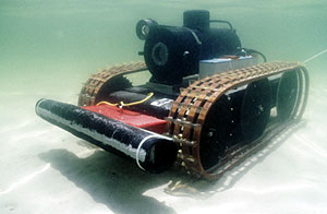
Robotic crawlers can carry sensors into very shallow water, or even into the surf zone. This robotic crawler, equipped with a camera and modem, can be controlled from substantial distances via acoustic communications. Photo courtesy of Benthos and the Naval Coastal Systems Station.
Lastly, acoustic communication technology is in the search for underwater objects. A robot crawler carries a modem, a camera, and a digital signal-processing unit. The robot, traversing the seafloor, searches for an object. When an object is found, the robot sends an acoustic signal to a ship or shore based station. The robot can then be commanded to take a still frame photo, compress the image, and transfer it as an acoustic signal that is sent back to the researcher. This technology allows archaeological expeditions to save thousands of dollars in diving time.
Additional Links on DOSITS
- People > How is sound used to communicate underwater?
- People > How is sound used to study undersea earthquakes?
- Technology Gallery > Hydrophone/Receiver
- Technology Gallery > Ocean Observatories
- Technology Gallery > Acoustic Modem
- Technology Gallery > Underwater GPS
Additional Resources
- 13 June, 2000., Submarine sends underwater e-mail. BBC News.
- NOAA Pacific Marine Environmental Laboratory (PMEL), Center for Tsunami Research: Deep-ocean Assessment and Reporting of Tsunamis (DART)
- NOAA National Centers for Environmental Information (NCEI): Deep-ocean Assessment and Reporting of Tsunamis
- NOAA National Data Buoy Center: DART buoy interactive map
- Woods Hole Oceanographic Institution (WHOI), Wave Glider provides gateway to remote exploration. https://www.whoi.edu/news-insights/content/wave-glider-provides-gateway-to-remote-exploration/
- Monterey Bay Aquarium Research Institute (MBARI), Wave Glider Hot Spot. https://www.mbari.org/technology/wave-glider-based-communications-hotspot/
References
- Teledyne Benthos – Acoustic Modems.
- Green, D. (2002). Large Area Monitoring of Marine Environments. In Seoul Ocean Seminar of the 1st APEC Ocean-Related Ministerial Meeting, Proceedings April 22-23. Seoul, Korea.