Tutorial: Study the Sea Floor
At the bottom of the ocean, there are layers of sediments that contain information about the Earth’s history. Sound is used to map and characterize these sediment layers. Sound is used to select the precise locations for coring or drilling sediment samples to study the history of Earth’s climate and ocean. Scientists also use sound to answer questions such as how and where earthquakes occur, how submarine volcanoes form, and what effects their eruptions have. Oil and gas are found in deposits below the seafloor and sound is used to find those deposits.
Sub-bottom profiling systems are used to identify and characterize layers of sediment or rock under the seafloor. The layers of the seafloor are examined with seismic reflection and seismic refraction (also called wide angle seismics). Echosounding is a basic type of seismic reflection.
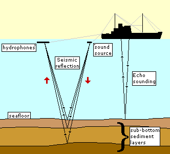
A sound source emits a sound pulse directed downwards towards the seafloor, and a receiver records the return of the pulse once it has been reflected off the seafloor. Parts of the sound pulse will penetrate the seafloor and be reflected off of the different sub-bottom layers. The data that is obtained using this system provides information on these sub-floor sediment layers.

Seismic reflection uses a stronger sound signal and lower sound frequencies (10-50 Hz) than echosounding in order to look deeper below the seafloor. The sound pulse is often sent from an airgun array towed behind a slowly moving ship. An airgun uses the sudden release of compressed air to form bubbles. The bubble formation produces a loud sound.

This is a picture of the bubble from an airgun off the U.S. Coast Guard Cutter Healy. Image courtesy of Paul Henkart, Scripps Institution of Oceanography.
Some of the sound reflects off the seafloor but some of the sound penetrates the seafloor, sometimes as much as 20-30 km below it depending on how the array is designed. The sound that penetrates the seafloor may also reflect off layers of sediment or rock within the seafloor. The reflected sounds travel back up to the surface. The ship also tows a number of hydrophones (called a towed array or streamer) which detects the reflected sound signal when it reaches the surface. They use many hydrophones to hear weaker reflections from deeper in the Earth.

Bathy 2000 Sub-bottomProfiler, Daisy Bank paper record. Photo Courtesy of NOAA OceanExplorer.
Features in the seafloor layers indicating that oil and gas might be contained in the rocks include salt domes and seeps. Salt domes were created when regions in the ocean repeatedly dried out. With all of the water gone, the salt in sea water was left as a layer. Over time, sea level rose again and the salt was buried by sediments. When salt is put under a lot of pressure and heat from overlying layers, it acts very similar to material in a lava lamp, gurgling and bubbling upward through the rocks above it. When it gets to the top, it forms an impenetrable layer that can trap oil and gas. Salt domes can be found using seismic reflection and refraction because of their unique shape and composition.
Seeps occur when oil and gas escape from the seabed and rise through the water column to the sea surface. Here is a picture of a methane seep in the Gulf of Mexico:

This image shows a large plume of methane-rich water, visible as a dark cloud, extending from the seafloor hundreds of meters up into the water column. At the base of the thermocline, some of the gas bubbles are trapped forming a horizontal layer of methane-rich water in the upper water column. Image by Mandy Joye, University of Georgia. From NOAA Ocean Explorer: Expedition to the Deep Slope (oceanexplorer.noaa.gov/explorations6mexico/welcome.html.
Scientists are using sub-bottom profilers to see what happens to oil and gas once they get into the water column. They are finding that some very small animals survive by using the oil and gas as food. The study of methane seeps may be a significant discovery in understanding the release of this greenhouse gas into the atmosphere.